… or along a walking trail. These are Emergency Markers and can be your gateway to help in an emergency as they save … On this page Emergency Parks, Reserves and Playgrounds PathsandTrails … We’ve upgraded our Emergency Markers …
Article Content
While out getting your daily exercise, you may have spotted a green sign with white text in one of our beautiful parks or along a walking trail.
These are Emergency Markers and can be your gateway to help in an emergency as they save our emergency responders time trying to locate you.
Each marker has a unique code that is linked to the Emergency Services Telecommunications authority (ESTA) system. When you call 000, knowing the location of your nearest marker can help ESTA quickly determine your GPS coordinates as well as nearest road access point and other navigational data to help emergency responders.
We recently conducted a full audit of our Emergency Markers to identify any damaged and missing markers within our parks and along our walking tracks. These have all now been replaced so emergency services can respond quickly where they are needed.
If you spot a damaged or illegible marker, please contact us to report this issue.
… at Andersons Creek Road, Doncaster East. On this page PathsandTrails Parking, Roads and Footpaths Roads and footpaths … …
Article Content
Andersons Road footpath is now complete!
Thank you to the community for your patience and understanding during construction.
Connecting our community through safe footpaths is one of the ways we’re building a better Manningham.
As part of our 2022-23 Capital Works Program, we’re constructing a shared path and footpath on Andersons Creek Road in Doncaster East to improve safety and accessibility.
Where is it?
We will construct the shared path and footpath on Andersons Creek Road (between Serpells Road and the service road at 101 Andersons Creek Road) in Doncaster East.
Why is the footpath needed?
As part of the bike networks strategy and principal pedestrian networks, we are continuing the shared path link along Andersons Creek Road and providing footpath access at Serpells Road.
When will the works happen?
The project will commence in late May 2023 and is expected to take one month.
If delays occur due to poor weather or unexpected events, we will let you know.
How will the works affect me?
There may be minor delays as works occur on site. Traffic control will assist with reducing impacts to motorists and moving traffic past the works.
We will contact residents whose properties will be directly affected.
We will make every effort to reduce any inconvenience to residents, motorists and pedestrians as we progress this project.
Thank you for your patience while we plan and undertake these important works.
Questions?
If you have any questions about these works or our footpaths program, contact us.
… Plan Harold Link is a Manningham Council owned drainage and sewerage reserve located between Millicent and Alfreda … avenues in Bulleen. On this page Capital Works Bolin Ward PathsandTrails … Progress is underway on the Harold Link Development …
Article Content
Harold Link is a Manningham Council owned drainage and sewerage reserve located between Millicent and Alfreda avenues in Bulleen.
After consultation with local residents around the use of Harold Link, key improvement areas were identified in drainage, access, landscaping and safety. With the addition of identified site constraints, these have been factored into the final design and Council would like to thank the residents for their input on this important local project.
Delivery of the Harold Link Development Plan has now commenced, with construction of an improved shared access path and new landscaping occurring in two phases.
The improved access path will:
better connect pedestrians and cyclists to Harold Reserve and the Koonung Trail network,
provide new landscaping with native and exotic trees, garden beds and grassed areas, and
drainage improvements including the modification and installation of new drainage pits.
… is seeking expressions of interest from organisations and community leaders to join its Healthy City Working Groups. On this page Active Manningham PathsandTrails … Be part of a healthy solution …
Article Content
Recognised as one of the state’s healthiest municipalities, Manningham Council is seeking expressions of interest from organisations and community leaders to join its Healthy City Working Groups.
Manningham Mayor Cr Andrew Conlon said Manningham was establishing three working groups and seeking people with a passion for health and wellbeing to participate.
“The working groups form part of Council’s broader wellbeing focus and will cover topics such as gender equity, youth mental wellbeing and resilience, and community connectedness,” he said.
“These working groups will support us in developing and delivering initiatives in these areas.”
Nominations are sought from people who live, work or study in Manningham and are interested in the ongoing development of health and wellbeing initiatives within the community.
Thirteen positions are available in each working group with a mix of individual and not-for-profit organisations.
Council encourages a diverse representation of the community including age, gender, cultural and ethnic backgrounds.
Expression of interest is open now until Friday 30 March.
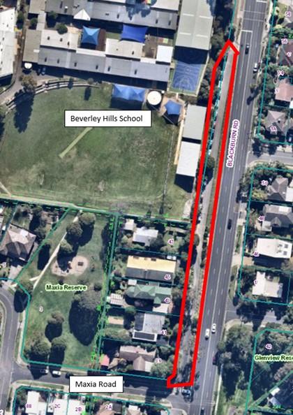
… Road service road, Doncaster East. On this page PathsandTrails Parking, Roads and Footpaths Roads and footpaths … …
Article Content
Connecting our community through safe footpaths is one of the ways we’re building a better Manningham.
As part of our 2023-24 Capital Works Program, we’re delivering some upgrades to improve safety and accessibility on Blackburn Road Road Service Road in Doncaster East.
The project will include the following upgrades:
a 1.2-metre-wide concrete footpath
enhancements to the existing car park in front of Beverley Hills Primary School.
a new underground drainage network to improve stormwater management.
a concrete kerb along the roadside to complement the new footpath.
asphalt resurfacing in front of properties 39 to 47.
a new sleeper retaining wall in various locations.
Where is it?
These works will be along the western side of the Blackburn Road Road Service Road, between Maxia Road and the Blackburn Road school, crossing to the north.
Why is the footpath needed?
The footpath works will improve pedestrian and traffic safety around the Beverly Hills Primary School, and the new underground drainage system will provide the residential properties with a formal point of discharge.
When will the works happen?
These works will likely commence during the school holidays in March 2024. The works will take around one month to complete, subject to weather conditions.
How will the works affect me?
Once works begin, please allow extra time for travelling safely through the area and follow directions indicated by signage and traffic controllers.
Sometimes, work will take place directly in the driveways of residential properties and within the road carriageway. At these times, there may be temporary disruptions to vehicle property access. Pedestrian access to properties will be maintained for the duration of the project.
We will contact residents and the school directly to discuss timing and disruptions closer to construction beginning.
We'll make every effort to reduce any inconvenience caused by these works, including scheduling the majority of the works to occur during the school holidays.
Thank you for your patience while we work to improve the roads, drains and footpaths in this area.
Questions?
If you have any questions about these works or our footpaths program, contact us.
… at Blackburn Road, Doncaster East On this page PathsandTrails Parking, Roads and Footpaths Roads and footpaths … …
Article Content
Blackburn Road footpath is now complete!
Thank you to the community for your patience and understanding during construction.
As part of our footpath Capital Works Program, we're constructing a footpath along Blackburn Road, Doncaster East. The footpath will improve accessibility and connectivity.
Where is it?
Blackburn Road, Doncaster East, between Chestnut Court and Anderson Creek Road.
The footpath will be constructed in two stages:
From Anderson Creek Road to Zerbe Avenue.
From Zerbe Avenue to Chestnut Court
Why is the footpath needed?
The new footpath will provide residents with a well-connected and safe all-weather footpath on the east side of Blackburn Road Doncaster East, between Chestnut Court and Anderson Creek Road.
When will the works happen?
The works are scheduled to start in January 2023.
We will provide updates if disruptions to the schedule occur.
How will the works affect me?
We may be required to close one lane of Blackburn Road. Appropriate detour signage and traffic management will be in place to assist with traffic flow and to provide guidance on access to your properties. We will notify residents whose properties will be directly affected.
We understand that this will cause inconvenience and will make every effort to minimise disruptions during construction.
Works will be programmed to minimise disruption to private properties and maintain emergency access and will generally be undertaken during normal working hours.
Questions?
If you have any questions about these works or our footpaths program, contact us.
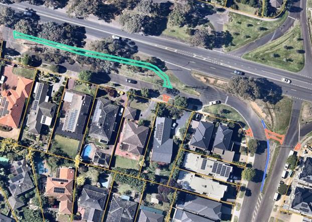
… Creek Road car park, Doncaster East. On this page PathsandTrails Parking, Roads and Footpaths Roads and footpaths … …
Article Content
Connecting our community through safe footpaths is one of the ways we’re building a better Manningham.
As part of our 2023/24 Capital Works Program, we’re constructing a shared path and upgrading the car park on Andersons Creek Road in Doncaster East, to improve pedestrian safety and accessibility.
Works will include:
construction of a shared path
installation of underground drainage, kerb and channel
sealing the asphalt in the car park
Where is it?
This car park is outside Mitre 10, along Andersons Creek Road. The shared path will connect the existing paths at either side of the car park.
Why is the footpath needed?
This footpath will connect the existing footpaths on Andersons Creek Road, improving pedestrian connectivity, and safety and accessibility around the car park.
When will the works happen?
Works began in March 2024, and are expected to be completed by the end of May, subject to weather conditions.
How will the works affect me?
Car parking will be modified for the duration of the works.
Please follow the directions of staff and signs to move safely around the area.
… are working with the Warrandyte Community Market Committee and other community groups to undertake tree protection works … Crown Land Reserve in Warrandyte. On this page Markets PathsandTrails Warrandyte Township … Environmental Improvements at …
Article Content
We are working with the Warrandyte Community Market Committee and other community groups to undertake tree protection works along the Yarra River Crown Land Reserve in Warrandyte.
Council commissioned an arborist’s report, which identified and prioritised trees that showed signs of stress due to vehicle and foot traffic at the monthly market. To protect these trees and ensure their longevity, logs and boulders will be placed around their root zones in November 2014 to act as natural barriers.
These works will improve the environmental amenity of the area, as well as reduce the market footprint and number of stalls. However, they will not significantly impact the Warrandyte Festival.
For more information, call Nancy Stokes on 9840 9138 (Monday and Wednesday).
… the health of the community, minimising traffic congestion and achieving environmental benefits. On this page Strategies, Plans and Policies PathsandTrails Parking, Roads and Footpaths … Bicycle Routes rolled …
Article Content
Manningham Council recognises the benefits of encouraging cycling as a sustainable mode of transport that is integral to improving the health of the community, minimising traffic congestion and achieving environmental benefits.
The Manningham Bicycle Strategy 2013 outlines bicycle routes and appropriate infrastructure to encourage more people to cycle in and around activity centres, reserves and other community hubs.
As part of the Strategy, bicycle symbols and complementary signage are being rolled out on some local streets to highlight to passing motorists that cyclists are in the area.
Manningham Mayor, Cr Paul McLeish said streets chosen for the preferred cycling routes have low traffic volumes and a speed limit of 50 kilometres or less.
“Bicycle symbols have been placed in the centre of some roads to ensure they are visible to both motorists and cyclists, and they are not obstructed by parked cars.”
“The symbols do not designate bicycle lanes or change existing parking arrangements. Residents are also reminded that the Victorian Road Rules require cyclists to ride to the left of the road, where possible,” he said.
Council is committed to encouraging mode shift and reducing resident’s reliance on private vehicles, with Australian Bureau of Statistics data indicating Manningham has one of the highest car ownership rates in metropolitan Melbourne.
For more information about the bicycle strategy and associated works, visit the Your Say Manningham website.
… us which dog friendly parks get your dog's wag of approval and here are your top 5 revealed. On this page Parks, Reserves and Playgrounds PathsandTrails Pets registrations … What are the top 5 dog friendly …
Article Content
We love our pooches in Manningham. You've told us which dog friendly parks get your dog's wag of approval and here are your top 5 revealed.
Get out and about and test out one of the top 5 on your next walk.
5. Finns Reserve
Perfect for dogs who love a long walk.
Duncan Street, Lower Templestowe
The surrounding bushland trails of Finns Reserve will let you and your dog be one with nature and keep away from the hustle and bustle of the streets.
In open spaces near Wombat Bend enjoy a game of fetch or tug of war. Don't forget that you will need to keep a distance of 15 metres from the playground.
Located near the Yarra River and managed by Parks Victoria, the off leash area at Banksia Park gives you stunning views while both you and your pooch stretch your legs.
If your furry friend wants to run off lead, the Cherry Blossom Loop of Banksia Park is fenced so you can easily keep your eye on dogs who may like to wander.
You can also pop a leash on your pet and take a walk around the rest of Banksia Park. Bring a rug and a bite to eat and enjoy the picnic perfect park.
The perfect place for your dog to show off to their doggy friends.
Eastway Avenue, Donvale
This is a great place for you to train your furry companion, for socialisation or agility training.
Aranga Reserve is Manningham's dog activity hub. The fully fenced dog activity centre will help keep your dog safe while they socialise with the other dogs.
Energetic pups can jump, crawl and climb using the range of agility equipment on offer at Aranga Reserve
Why not make it a family outing, and bring a picnic to eat at the nearby picnic tables and let your children have fun on the playground.
Head to Warrandyte for your next dogs' day out and let them take in the sights and smells that beautiful Warrandyte has to offer.
Sit by the tranquil and picturesque Yarra River and simply watch the world go by. Or explore the walking trail with your canine companion, enjoying the natural bush area.
Finish your day with a treat at one of the many local cafes - a great day out for humans and dogs.
Enough space for your dogs to roam to their heart's desire - it’s the park that has it all
There are plenty of walking tracks throughout the park or if running wildly through the grass is your dog's thing, then Ruffey Lake Park is all their doggy dreams come true.
If all that running has made you and your pooch thirsty, then refresh at one of the pet friendly drinking fountains.
With plenty of playgrounds, barbecues, picnic tables and toilets, you can make it a full day outing with the whole family.
To protect vegetation in the park, there are some areas that are fenced, so please remember to keep your dog out of these areas. Plan your next trip to Ruffey Lake Park with your dog.
… mouth Manningham has a number of dog-friendly open spaces and invites the community to nominate their favourite. As … dog park. On this page Parks, Reserves and Playgrounds PathsandTrails Pets registrations … Straight from the pooch’s mouth …
Article Content
Manningham has a number of dog-friendly open spaces and invites the community to nominate their favourite.
As part of its Top 5 Manningham series, launched earlier in the year, Council will be opening a poll for residents and their pooches to vote for their favourite dog park.
Manningham Mayor Cr Andrew Conlon said Manningham had a lot of fantastic on and off-leash dog parks for residents and their four-legged friends that encourage everyone to get out and about.
“One of the key themes in Council’s four-year plan is fostering healthy communities,” he said.
“Dog parks provide a safe place for pets and their owners to gather for both exercising and socialising.”
The poll is available on Council’s website and is open to everyone until 5.00pm, Monday 5 March, with results revealed shortly after.
Earlier in the year, the community nominated Ruffey Lake Park in Victoria Street Doncaster East as the top playspace.
Its plentiful play equipment, picturesque scenery and safe walking tracks were some of the many reasons it was voted in at the top spot.
Wombat Bend in Lower Templestowe, Currawong Bush Park in Doncaster East, Federation Playground at Warrandyte River Reserve and Manna Gum Playground in Doncaster East rounded up the top five play spaces in Manningham.
Photograph and interview opportunities are available.
… Discover the Great Outdoors: Accessible Walking Trails in Manningham Walking paths around Victoria have been audited and turned into digital walking maps as part of a project …
Article Content
Victoria Walks have created 26 digital maps of accessible walks around Victoria, giving people with disability greater access to nature walks.
Walking paths around Victoria have been audited and turned into digital walking maps as part of a project giving people with disability greater access to nature walks. This partnership between Victoria Walks and Scope Australia has been supported by the Victorian Government Access for All Abilities initiative.
So far they have completed 26 digital maps of accessible walks and the walks have been audited by people with disability, for people with disability.
Take some time to explore the great outdoors with some of these wonderful walks in Manningham
… the Eastern Freeway to 20 lanes will increase noise and pollution. We are advocating for the best possible outcomes in relation to noise control and visual impacts, shared pathsand to protect the Koonung Creek Linear Park and …
Article Content
Widening the Eastern Freeway to 20 lanes will increase noise and pollution. We are advocating for the best possible outcomes in relation to noise control and visual impacts, shared paths and to protect the Koonung Creek Linear Park and overall amenity of the area. There should be no encroachment of the road beyond the freeway reservation and the Koonung Creek Trail and reserve should be protected as much as possible.
Residents who live next to the Eastern Freeway must be protected from noise and impacts to their surroundings should be minimised. High quality and aesthetically suitable noise barriers and retaining walls should be installed ahead of the widening to set new international benchmarks along adjoining roads. Replanting and landscaping should be undertaken to the highest standard for ecological and visual performance. The Eastern Freeway should remain free of all tolls on all traffic lanes including merging or express lanes.
Where are we now
Expert Witness Report - North East Link Project, Social and Community Outcomes in City of Manningham
Expert Witness Report - North East Link Project, Social and Community Outcomes in City of Manningham